The four pillars of SCT are described as geotechnical; research, consulting, fields services and instrumentation with considerable overlap across these groupings. The research category would usually be categorized as scientific research however this story is about historical research.
As part of a subsidence assessment and other mining approval process requirements for a multi-seam mining operation, SCT has undertaken research in the reliability of the historical mine plan records for this triple seam site.
Steve Wilson conducted the majority of this work. Steve has a background in underground mine surveying and mine planning with over 40 years’ experience including more than 25 years in a statutory role. During this time, he has developed a personal interest in the interpretation of historical mine plans for hazard identification (e.g.Inrush). Steve was well placed to undertake this having worked at the site and the adjacent mine for more than 15 years.
The purpose of this research was to identify areas of potential, marginally stable pillars to assist in quantifying residual risk for greater than predicted subsidence and to assist in considerations for a Principal Hazard Management Plan to manage the risks to health and safety from subsidence. Key to quantifying the risk to natural or built features and health and safety is an understanding of the status of the overlying goaf areas in the old workings stretching from about 1880 to 1950.
This research was undertaken with an appreciation of the evolution of mining methods and the history of surveying for and the drafting of mine plans in NSW.
There was much discussion regarding the reliability of the historical mine plan data during the environmental impact assessment process for the project and the risk resulting from any uncertainty and assumptions based on poorly defined or unknown information. Reliability, in this context, refers to accuracy, completeness and the somewhat subjective, percentage of extraction of the coal seam depicted by the drafting standards at the time the plans were prepared.
The areas of greatest concern were the sections shown as goaf polygons where the details of secondary extraction were not shown and could not be confirmed as collapsed (and subsided) by some other method. The practice of outlining an area of secondary extraction with a polygon and a notation of “goaf” or something of similar meaning is not usual on plans from this era. This practice was commonly used on some older mine working plans and duplicated during the creation of ‘record tracing’ plans many years later.
The research and assessment included examination of detailed mine plan records (mine or colliery working plans, record tracings and other subsidiary plans such as for production, ventilation) and other records for the site held by the mining company, Department of Mineral Resources, University Library Archives, Public Library – Local studies section and most significantly, the AusIMM – Illawarra Branch – Mineral Heritage sub-committee. Similar exercises were undertaken for the adjacent mines.
Assessment of the status of the goaf also considered the data from surface to seam(s) and inter-seam boreholes, analysis of subsidence monitoring measurements, pillar stability assessments and observations of seam interaction effects from underground inspections.
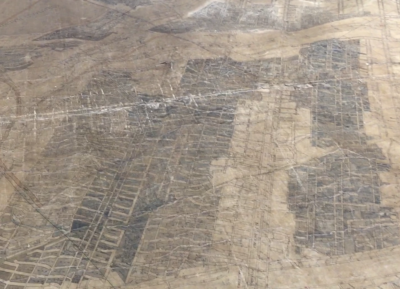
After years of ongoing research and assessment the breakthrough came recently through a professional and personal connection to AusIMM and an original mine working plan in their possession.
This “missing” plan from AusIMM, and earlier mine working plans, provide the details of the mining up to about 1932. The later series mine working plans and record tracings, provide the details after 1931. For the areas of interest to the planned third seam of mining, the complete details of the goaf areas in the upper seam, recorded at the time of mining, can now be pieced together by combining the information shown on all available plans.
The video below provides a sneak peak of the plan we're calling the “missing link”. This is an old linen plan shows mine workings from 1860's and this plan started circa 1904.
It is reassuring to note the interpretation and assumptions made in previous assessments are consistent with this detail. The intention has been to provide understanding and advice for safe and productive mining while finding an appropriate balance between resource recovery and environmental impacts.
This recent break-through is seen as reward for the years of tenacity and perseverance.